|
2.7 VOYAGE PLAN
While the vessel is in the discharge port the master should receive
the orders for the next voyage. It is his duty to plan the route for
the voyage to the next loading port in accordance with the requirements
of the owner, the charterer and good seamanship. The basic requirements
are safety, efficiency and economy. The main objective is safety of
the crew, vessel and cargo. The ship must be provided with the latest
navigation chart editions, corrected to the date of the latest notice
to mariners on board. Radio navigation warnings must be reviewed to
verify that the proposed route does not encounter any temporary hazard.
The plan should be prepared using an owner approved checklist, indicating
all information sources to be reviewed to properly complete the plan.
2.7.1 Owner's voyage instructions
The primary guidance for voyage planning are the guidelines set down
by the vessel's owners. The owners should require strict compliance
with the Convention on the international regulations for preventing
collisions at sea, exclusion and separation zones and established
policies for under-keel clearance, distances navigation hazards are
to be passed, etc. They may also indicate how the voyage track is to
be marked on the charts and how it should be verified.
Normally the voyage track will be drawn on the voyage charts by the
master or ship's navigator and verified independently by the master
or a second officer. Each leg of the voyage track must be measured to
determine its length in nautical miles and the true course. A written
voyage plan is prepared while courses are being laid down on the chart.
The voyage plan should indicate:
The watch conditions expected to be set at each leg of the voyage.
Frequency of position fixing and navigation aids to be used. Where/when
the master is to be called.
Seasonal considerations and weather routing.
Minimum distance(s) off for passing navigation hazards.
Passage plans for restricted waters are particularly important as
these are the most difficult and dangerous parts of the voyage. All
officers should review the plan during preparation and be fully aware
of its details.
The true course of each track segment must be marked on the chart. On
some ships, the sounding line representing the shallowest navigable
water for the ship is coloured in with red ink, as are all submerged
hazards in deeper water. Owner's instructions regarding navigation in
ice and use of weather routing services must be followed unless they
conflict with the charterer's instructions, in which case the owner
must be advised requesting clarification. In any case where the master
is in doubt about the voyage orders, or believes that a more efficient
or safe voyage plan could be used, he is required to proceed on the
safest course while advising the charterer and requesting clarification.
Owners will indicate if master is to participate in the automated merchant
vessel reporting (AMVER), system operated by the US Coast Guard.
2.7.2 Charterer's voyage instructions
The voyage objective of the charterer is to get the vessel to the next
port as rapidly as possible. Intelligent charterers will issue voyage
planning instructions which place safety foremost, but they will also
expect the maximum of efficiency and economy within those guidelines.
Charterers expect the ship to be adequately provided with charts, publications
and the latest navigation notices and warnings. Traffic separation schemes
and ice navigation, speed, ballast, reserve bunkers, and water and timing
of arrivals are usually discussed in charterer's instructions. Any navigation
decisions which have a commercial impact should be communicated to the
owner and charterer to avoid later claims for deviation or lack of adequate
speed performance.
Charterers will indicate to the master, as necessary, the ship's drafts
for entering or leaving the ports. Drafts will always refer to seawater
of specific gravity 1.025 unless indicated otherwise. The master must
satisfy himself that the indicated loading or arrival draft is correct
for the circumstances by reviewing the latest harbour and berth depth
information available to him.
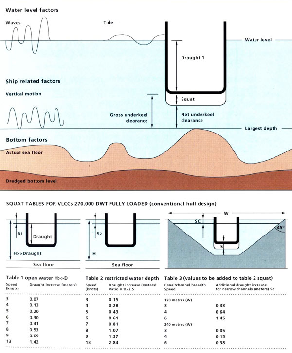
2.7.3 Safe depth
A safe depth is one which provides adequate under-keel clearance. To
properly evaluate the safety of any track line which enters shallow
water the master must consider:
The chart datum.
The stage of the tide while transiting.
Effects of the weather on water levels.
The actual draft of his ship allowing for trim 'squat' and list.
The accuracy of
the chart surveys.
Failure to account for these effects can produce an under-keel clearance
much less than that obtained by simple subtraction of the draft from the
charted depth.
Squat in shallow water can be calculated by the formula:
SQUAT = (2 x Cb x Vs^2) = centimetres Cb - block coefficient Vs - speed
in knots
The most important part of this equation is the squared variable -speed.
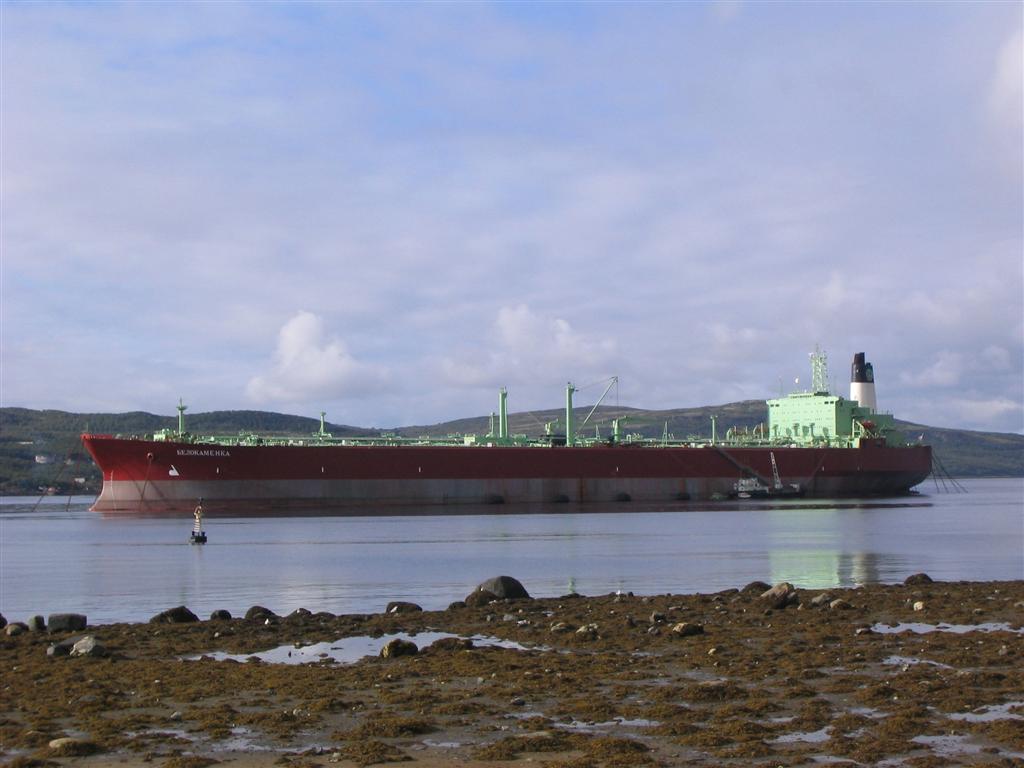
The effect of speed is apparent when a fully loaded 270,000 DWT VLCC
proceeding at eight knots in shallow water will squat 1.1 meter, while
at thirteen knots in shallow water the same ship squats nearly three
meters! The effect is magnified further in dredged channels, adding
more than a meter to the draft of a 270,000 DWT very large crude carrierVLCC
travelling at six knots in a narrow channel. This is in addition
to the shallow water depth squat increase.
Squat is only one of the variables which determine
underkecl clearance.
It is clearly important to provide a large extra margin of under-keel
clearance for those shallow areas which the master intends to pass at
full speed. Where under-keel clearance is less than three meters the
master should:
a Reduce speed to the minimum necessary to provide
steerage.
b Increase steering ability when turning by putting
the rudder over first then'kick' to the rudder with short bursts of
higher engine speeds.
c When under pilotage, discuss speed and squat with
the pilot and agree on a maximum safe speed for the transit. Remember
that the pilot is only an advisor. If the master believes that a slower
speed should be used than that recommended by the pilot, then the master's
view shall prevail.
If excessive vibration is experienced while transiting shallow water,
then the vessel's speed should be immediately reduced to minimise squat
and increase the under-keel clearance.
Vessel list increases the vessel's effective draft. For a ship with
a 40 meter beam, each degree of list increases the effective draft amidship
by 35 centimetres. A three degree list would increase this ship's draft
by more than one meter. Where draft is critical, the ship should be
placed on an even keel before proceeding.
The heeling effect produced by the rudder when making a turn must be
considered and the speed of the ship adjusted when approaching turns
to minimise rudder induced list.
Shallow water increases the turning circle of all ships. The turning
diameter of a deeply laden VLCC will be doubled in conditions of restricted
under-keel clearance. Deep draft vessels should avoid meeting other
ships at turns or bends in shallow channels.
Vessel turning behaviour in shallow channels requires that the master/pilot
always indicate the amount of counter rudder required to check the swing
of the ship. Never leave the amount of counter rudder to the quartermaster's
discretion in shallow waters. If the vessel is proceeding at moderate
(half), speed in shallow water, additional engine revolutions can always
be called for to increase rudder force. This cannot be done if the ship
is already at full speed.
Proceeding in shallow channels with minimum under-keel clearance will
reduce the speed of the ship, in some cases by 2/3!
Deep draft vessels navigating in shallow channels should not overtake
other vessels.
Deep draft vessels navigating in narrow channels should display the
'constrained by draught' signal as appropriate.
2.7.4 Separation schemes
The provisions of the international rules concerning compliance with
published traffic separation schemes must be followed when preparing
a voyage plan.
Where there are established major shipping routes, such as in the North
Atlantic, the voyage should be planned to follow these routes, or at
least laid down in such a way that the track does not conflict with
the route recommended for vessels proceeding the opposite way.
The IMO publication Ship routing and other national voyage
planning guides summarise the internationally accepted ship routing
schemes.
2.7.5 Weather routing
Weather routing services have as their objective indicating the 'least
time route' for the ship. The distance recommended may be greater, however
the time spent in adverse weather will be less. That advantage usually
means that the ship arrives earlier than it would if it had fought its
way through adverse weather on the shortest great circle track. The
charterer will advise details of using his weather routing service.
In the absence of such advice, the owner should utilise weather routing
to minimise weather damage to the ship and cargo and weather stress
on the crew.
Allowance for ice conditions must be made in planning the voyage. Non-ice-classed
ships must remain well clear of any area where consolidated pack ice
is likely to occur. If an area subject to ice must be approached, then
the master must obtain the best and most recent ice information from
local authorities. Additional lookouts may be necessary if the vessel
is passing an area where ice is suspected or reported, especially bergs
or floes. Vessel speed must be adjusted at night in accordance with
SOLAS 1974, Chapter V, Regulation 7. When a ship must transit
pack ice conditions the appropriate icebreaker service must be contacted
to arrange escort. If icebreaker services are arranged in convoys, the
ship must follow the instructions of the controlling icebreaker.
Masters unfamiliar with ice navigation should engage an ice pilot for
that portion of the voyage. If a dedicated icebreaker escort is not
available, the ship must wait for the next ice convoy. The master always
retains full authority to abandon a voyage if, in his judgment, the
ship would be exposed to serious danger in proceeding as planned. The
master should keep in mind that although some time is lost by abandoning
a voyage, this will be less costly for the owner than ice penetration
of the hull with resulting oil pollution and damage repair costs.
2.7.6 Prohibited zones
Tankers which will wash tanks and decant slops or dirty ballast during
the voyage must plan a route which places them outside coastal or oceanic
prohibited zones long enough to conduct these operations within the
requirements of MARPOL.
2.7.7 Oceanic currents
Tankers which will prosecute their voyages at reduced speed should carefully
examine the prevailing currents for the waters to determine if the voyage
plan can be adjusted to avoid adverse currents or make the best use
of favourable ones. For example: when proceeding northbound on the southeastern
US coast, Gulf Stream 'western wall' advisories can be obtained from
shore radio stations. By setting a slow-speed vessel's track ten miles
to the east of the Gulf Stream's 'western wall' considerable additional
distance can be made at no additional cost in fuel.
2.7.8 Pilotage
The requirement for a voyage plan includes the portion of the voyage
which will be completed under pilotage. The master should prepare a
departure and arrival plan which includes pilotage waters and review
the plan with the pilot before proceeding.
2.7.9 Bunkers
The master, in conjunction with the chief engineer and the first officer,
must calculate and confirm that the bunkers carried are sufficient for
the voyage to be undertaken. This calculation requires that the true
caloric content of the fuel and the operational losses be considered.
Recommended reserves should never be less than three days for full speed
steaming, and will vary with the length of the voyage and the season
of the year.
Any fuel conservation programs required by charterer's should be followed
diligently by the master and chief engineer.
2.7.10 Timing of arrivals
Unless otherwise instructed by charterer's, masters should proceed at
the indicated speed to the arrival port, even though it is apparent
that there will be a delay after arrival. The reasons for this are:
The arrived vessel may use the time to conduct necessary repairs or
maintenance,
The ship will reserve an earlier position in the berthing order where
'first come - first berthed' procedures apply and
The anticipated spare time may be consumed en route by weather,
mechanical or traffic delays.
2.7.11 Publications
Master and owner have a responsibility to ensure that a comprehensive
set of the latest navigation publications are provided to the vessel.
Notices to mariners and publication changes must be obtained
when published and dispatched to the ship's next destination by the
quickest method.
|